Project region
General Problems of Water Provision in Karst Regions
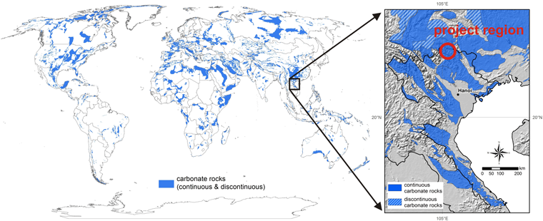
More than 25% of the world's population live on carbonate rock and/or are dependent on water supply from karst aquifers. Due to high rates of seepage and lack of reservoirs on the surface, karst regions are often characterized by considerable water shortage. Simultaneously, there exist enormous deposits in underground cave systems, whose utilization however entails significant effort, due to heterogeneous distribution and seasonal fluctuations in supply. Added to this is the high risk of contamination due to the low filtration capacity of karst rock. This gives rise to enormous obstacles to establishing conventional water supply systems for karst regions, especially in emerging and developing nations.
|
|
| Karst deposits worldwide and in the project region in the north of Vietnam (modified, Chen et al. (2017)) |
Location of the Project Region
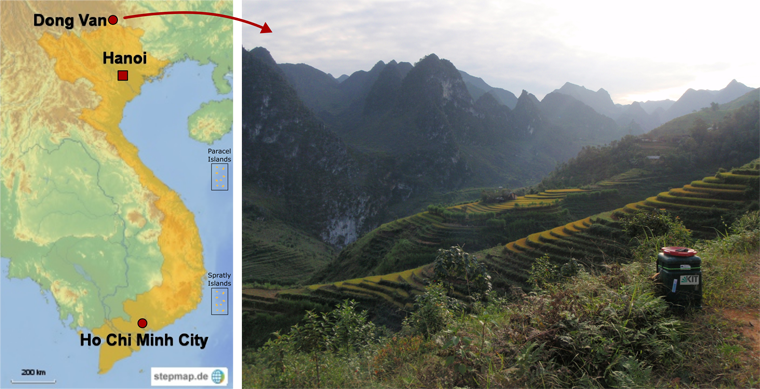
Vietnam is located on the east coast of Southeast Asia and is bordered by China to the north, Laos to the west, and Cambodia to the southwest. The country stretches over a distance of 1650 km from north to south, while the breadth at its narrowest point measures just about 50 km. The south of Vietnam is characterized by extensive plains, while the north, on the other hand, has rocky mountain ranges with heights of over 3,000 m+NN. The landscapes in the north with their irregular heights and morphological characteristics as well as a multitude of plateaux can, in particular, be ascribed to the oft-occurring karst bedrock.
The project region is located in Ha Giang Province and extends over the four districts located in the extreme north of Vietnam, Quan Ba, Dong Van, Meo Vac, and Yen Minh. In the year 2010, the karst landscape of these districts was included in the UNESCO Global Geoparks Network as Dong Van Karst Plateau. The region is the first official UNESCO Geopark in Vietnam and the second in the whole of South East Asia.
|
|
| Location of the project region in Dong Van, Ha Giang Province, northern Vietnam (left), landscape in the Dong Van Karst Plateau (right) |
Topography and Geology
About half of the project region consists of limestone, the other half consists of other rock types such as siltstone, mudstone or sandstone. The highly dissected topography with ground elevations of up to 2,000 m+NN is characterized by karst hills with deep valleys and gorges. The rural population lives in settlements and individual farmsteads that extend over a height of about 700 to 1,500 m+NN. The district capital, Dong Van City, is located at a height of about 1,050 to 1,080 m+NN. The Seo Ho River has its source in a cave system at a height of about 930 m+NN and flows through the project region before flowing into the border river between Vietnam and China at a height of approx. 500 m+NN. Other surface water bodies in the region can be found within a range of approx. 200 to 400 m+NN.
Climate, Hydrology, and Hydrogeology
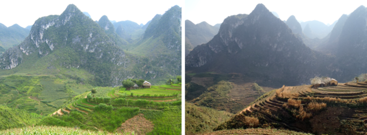
The region is characterized by a subtropical climate with pronounced rainy (May to October) and dry seasons (November to April). Apart from the topographical and climatic conditions, the hydrogeological conditions also lead to residents suffering from partly significant water shortage.
Due to the high porosity and infiltration rate of the karst, runoff activity shifts to underground cave systems, with there being little constant surface runoff and no natural, aboveground reservoirs. The only exceptions are areas with different rock characteristics, with the region under investigation being characterized by streams that flow into the subsoil by means of ponors and, with large runoff fluctuations, resurface at different springs. Due to the topography, the water covers enormous differences in altitude both on the surface and in the subsoil.
The hydraulic interaction between streams, caves, and springs as well as the retention and storage characteristics of the aquifer including the morphodynamic processes in the aquifer systems were mostly unknown at the commencement of the consortium's activities. In this regard, the current results achieved by the R&D consortium enable an extensive understanding of local and regional hydrogeological processes.
|
|
| The project region in the rainy season (left) and dry season (right) |
Settlement Structure and Water Supply
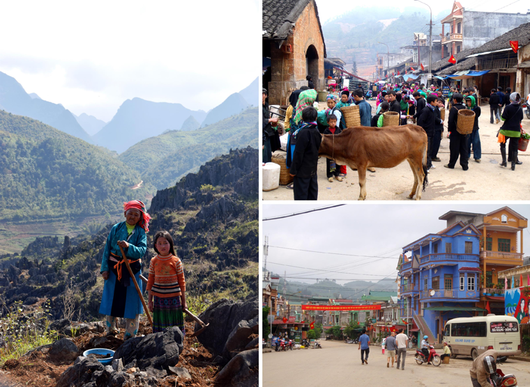
The population principally lives in distributed settlements in mountainous regions as well as in individual urban areas (especially the district capitals) and is mainly dependent on agriculture for its livelihood. The few surface water resources and/or streams are located, in part, hundreds of meters beneath the settlements, with great pumping heights and distances having to be covered to utilize them. Combined with precipitation focused on a few months, as is typical of (sub)tropical regions, this leads to seriously deficient water supply especially in the dry season.
|
|
| Difficult living conditions for the local population, which is principally dependent on farming and animal husbandry as well as up-and-coming tourism for its livelihood |
Water supply in rural areas relies on decentral and individual methods, which always come at great cost. For example, people collect rainwater during the rainy season and use canisters to transport well water to the households during the dry season. To improve the supply situation in many places, the government opts for the use of central, flatly constructed water collection reservoirs (hanging pools). Apart from the limited quantity though, the water resources available there are characterized by highly limited water quality due to natural (contamination) and anthropogenic factors (e.g. using the reservoirs as washing areas). The considerable construction costs, high evaporation rates, and structural defects can be identified as further disadvantages.
|
|
| Individual water transport by children and women (top left), use of domestic tanks within the grid-bound distribution system of Dong Van City (top right), open water collection point ("hanging pool", below) |
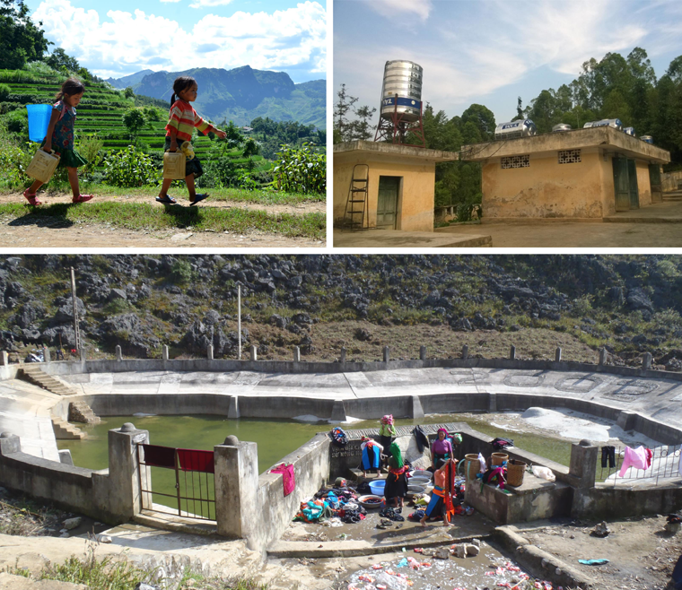
A central grid-bound supply system exists only in the district capital, Dong Van City. Local supply primarily depends on a karst spring, which is typically characterized by variable fill rates and limited water quality. As is common in such regions, water provision occurs intermittently to keep water losses as low as possible due to limited supply combined with the dilapidated state of the water supply network. Apart from temporally restricted water provision, this mode of operation also directly leads to further worsening of water quality through the entry of contaminants and to higher strain on the distribution network, for instance, through variations in pressure.
As regards water supply, further difficulties arise from regional tourism. An exponential increase in visitor numbers has thus been recorded in the past few years, which can be, inter alia, attributed to the inclusion of Dong Van Karst Plateau in the UNESCO Global Geoparks Network in the year 2010. Although this situation offers opportunities for economic development, it also inevitably leads to the exacerbation of problems of supply in the water sector.